ASSETS
Nieuws en bijeenkomsten die je slimmer maken.
Collect data for precision agriculture
Bodem- en gewassensoren kunnen worden ingezet om relevante data te verzamelen over de toestand van de bodem of over de stand en groei van het gewas op een bepaald perceel. De verzamelde data kan vervolgens worden verwerkt tot een taakkaart, waardoor de conditie van de bodem en de actuele groei van het gewas in beeld kan worden gebracht. De taakkaart kan vervolgens worden gebruikt bij verschillende teeltmaatregelen, zoals bijvoorbeeld het plaatsspecifiek bemesten.
Het Fieldlab Sensoren is onderverdeeld in vier groepen:
- Soil sensors
- Crop sensors
- Weather stations
- Other sensors
Soil sensors
Using soil sensors, soil moisture tension can be measured. This makes it possible to visualise the moisture status of the soil. This data can tell real-time something about the water availability of plants.
In addition, some soil moisture sensors can be linked to a weather station, here the collected data from both the sensor and the station can be linked together. This makes it possible to determine the ideal irrigation timing. The following soil moisture sensors are available at the practice centre:

TerraSen Pro sensor - Soil moisture station from Dacom
The TerraSen Pro sensor provides data on the moisture situation in the soil. The sensor measures soil moisture and soil temperature in five layers, from 10 centimetres to 50 centimetres. The sensor is linked to a weather station. This weather station measures precipitation, wind speed and radiation on a particular plot. Using this data, the right irrigation timing can be determined with the right amount in the right place. With this, irrigation management can be optimised. The data can be found on a web application and a mobile app from Dacom.
Farm21
The Farm21 is also a sensor, which can collect and then image soil data. The Farm21 measures soil moisture at three different depths, from 0-10 centimetres to 20-30 centimetres. It also measures soil temperature in the topsoil layer (10 centimetres deep), as well as some weather data. This weather data, such as air temperature and humidity are measured with the Farm21 below the crop. This is because the Farm21 sensor is attached under the crop. The data can be found on the Farm21's platform. In addition to the Farm21, the practice centre also has the Farm24.
Crop sensors
Using crop sensors, it is possible to image plant growth. Also called crop sensing. This is done by capturing the amount of reflected (sun) light. This is an index for plant growth, as a plant absorbs (sun)light and light that is not absorbed is then reflected back. Based on this, a biomass or chlorophyll map can be made.
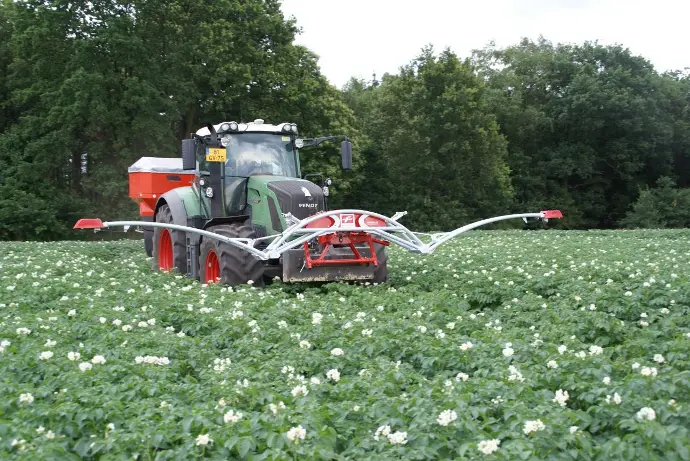
Fritzmeijer Isaria
The Fritzmeijer crop sensor makes it possible to collect data on crop growth. These sensors are often attached to a tractor or a machine, for example the sprayer or fertiliser spreader. This makes it possible to create a task map of the current crop growth at each operation in the field. Crop growth is visualised as the Fritzmeijer sensor captures reflected light. Based on this, vegetation indices can eventually be measured.
Weather stations
In precision agriculture, it is important to apply the right crop measure, in the right place, at the right time. The time of application depends, among other things, on weather conditions. To apply a crop measure at the right time, it is important to visualise the current weather influences. This can be done using weather stations. With the current weather conditions, the right spraying moment can be advised or the right irrigation moment can be determined, for instance.
Wolkytolky
The WolkyTolky is a weather station, which measures various weather data. For example, the following data is measured by the weather station:
- Precipitation
- Temperature
- Wind force + wind direction
- The relative humidity
- Solar power + UV radiation
- Leaf wetness, which can be an important indicator of disease pressure.
Soil moisture and soil temperature can also be measured with WolkyTolky's weather station.
It is also possible to connect to a data centre via a mobile network or app. This can show current developments on the plot and the app can alert the grower when a set value is reached or exceeded. An example of a set value is a certain percentage of soil moisture. When the percentage is almost reached or exceeded, the grower can be alerted via the app. Based on this, the grower can react in time and a possible moisture deficit can be prevented.
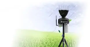
Sencrop
Sencrop's weather stations make it possible to collect agro-weather data from the field. This data from Sencrop's various weather stations, can then be linked to an advisory module, also called a Decision Support System (BOS system). In this way, the right decision can be made, for an effective outcome of the measure and the input product, for example, can be reduced. An example is determining the right spraying moment, with a lower dosage of crop protection product. In addition, Sencrop makes it possible to analyse data from other weather stations in the area. Sencrop's available weather stations at the practice centre are the Raincrop and the Windcrop.
- Raincrop: Sencrop's Raincrop can be used to measure local agro-weather data such as (cumulative) precipitation, temperature, humidity, wet bulb temperature and dew point.
- Windcrop: With the Windcrop, it is possible to treat the crop at the right time and ensure the most effective cultivation measure possible. For example, the Windcrop measures wind speed, wind direction and possible wind gusts.
Other Sensors
Besides soil sensors and crop sensors, there are other sensors that can be used to collect data. These sensors have already been mentioned and explained in other fieldlabs where they are applicable, they are briefly outlined below.
NIRXact-sensor
A NIRXact sensor can be used during the spreading of animal manure. With this sensor, it is possible to visualise quantities of certain values from the manure, per certain zone. An example of a value is the amount of nitrogen. Thus, the added values of nitrogen at a specific spot, can be accurately visualised.
UAV-sensing
UAV sensing (Unmaned Aerial Vehicale), is also known as aerial monitoring (of a plot or crop trial) using drones. Using UAV sensing of the crop, various data can be collected. For instance, data can be collected on the current growth of the crop or weed patches can be visualised. This data can be collected using different cameras, which can be used on the drones
Remote-sensing
To image actual crop growth from the air, it is also possible to use sensors attached to satellites. This is also known as remote sensing. This technique of sensing also makes use of sunlight by capturing the reflected sunlight with the sensors. The data from the satellites is then processed into images, these images can then say something about plant growth.
ONZE CONTACTGEGEVENS
Postelsedijk 15
5541 NM Reusel
Nederland
E info@vdbornecampus.com
T +31 (0)497 641 878
VOLG ONS